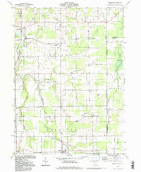
1994 Map of Pierpont
USGS Topo · Published 1997About this map
The Ashtabula River and Conneaut Creek systems define this landscape along the Ohio and Pennsylvania border in the 1990s. The area maintains a rural, resource-focused character where agricultural roads like Beckwith Road and Hilldom Road connect small settlements. Dozens of Gas Wells and Oil Wells are scattered across the townships of Monroe, Beaver, and Pierpont, indicating a sustained reliance on sub-surface energy extraction. Local history is anchored by several historic sites, including the Monroe Sch and multiple burial grounds such as Evergreen Cem and Reeds Corners Cem. A notable Covered Bridge on the Ashtabula River and the eastern edge of the State Game Lands No 101 provide clear points of reference for those tracing the transition from working land to conserved spaces.
Find a feature on this map
50 named features on this map. Tap any name to fly to it.
Don’t see what you’re looking for? This feature index may not catch every label — zoom into the map to look around manually.
Map Details
Editions of this 1994 Pierpont Map
This is the sole edition of this map. No revisions or reprints were ever made.
Other maps of this area

1900 · Girard
USGS Topo · 1:62,500

1905 · Andover
USGS Topo · 1:48,000

1906 · Conneaut
USGS Topo · 1:62,500

1906 · Linesville
USGS Topo · 1:62,500

1907 · Andover
USGS Topo · 1:62,500

1908 · Linesville
USGS Topo · 1:62,500

1950 · Cleveland
USGS Topo · 1:250,000

1956 · Cleveland
USGS Topo · 1:250,000

1959 · East Springfield
USGS Topo · 1:24,000

1959 · Beaver Center
USGS Topo · 1:24,000