
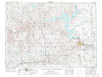
1954 Map of Pierre
USGS Topo · Published 1968About this map
The Oahe Reservoir dominates the center of this mid-century landscape, capturing the massive scale of the Missouri River water management projects. To the north and west, the vast Cheyenne River Indian Reservation spans across the Cheyenne River valley, marked by traditional place names like No Heart Butte and Artichoke Butte. The state capital at Pierre sits at a geographic crossroads where the river meets the Chicago and North Western rail line.
Find a feature on this map
95 named features on this map. Tap any name to fly to it.
Don’t see what you’re looking for? This feature index may not catch every label — zoom into the map to look around manually.
Map Details
Editions of this 1954 Pierre Map
2 editions found
Other maps of this area

1924 · Pierre
USGS Topo · 1:62,500

1934 · Canning
USGS Topo · 1:48,000

1937 · Canning
USGS Topo · 1:62,500

1937 · Oahe
USGS Topo · 1:62,500

1951 · Capa
USGS Topo · 1:24,000

1951 · Van Metre
USGS Topo · 1:24,000

1951 · Capa NW
USGS Topo · 1:24,000

1951 · Capa SE
USGS Topo · 1:24,000

1953 · Belvidere NE
USGS Topo · 1:24,000

1953 · Teton
USGS Topo · 1:24,000