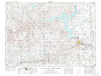
1954 Map of Pierre
USGS Topo · Published 1977About this map
Pierre serves as the focal point for this expansive central South Dakota landscape, situated at the confluence where the Bad River meets the Missouri River. The mid-century geography is dominated by the massive waters of Lake Oahe and Sharpe Lake, reflecting the transformative impact of the Pick-Sloan Plan on the river valley. To the north and west, the Cheyenne River Indian Reservation spans the rugged breaks of the Cheyenne River, while the surrounding prairie is dotted with isolated settlements like Milesville and Mission Ridge. The map illustrates a transitional period for regional transport, showing the Chicago and North Western rail line and established agricultural hubs such as Onida and Agar. Significant topographical markers like Medicine Knoll and Sully Buttes rise above the plains, providing landmarks that have guided travelers from the era of indigenous trails to the modern highway network of roads like 83 and 34.
Find a feature on this map
86 named features on this map. Tap any name to fly to it.
Don’t see what you’re looking for? This feature index may not catch every label — zoom into the map to look around manually.
Map Details
Editions of this 1954 Pierre Map
2 editions found

Other maps of this area

1924 · Pierre
USGS Topo · 1:62,500

1934 · Canning
USGS Topo · 1:48,000

1937 · Canning
USGS Topo · 1:62,500

1937 · Oahe
USGS Topo · 1:62,500

1951 · Capa
USGS Topo · 1:24,000

1951 · Van Metre
USGS Topo · 1:24,000

1951 · Capa NW
USGS Topo · 1:24,000

1951 · Capa SE
USGS Topo · 1:24,000

1953 · Belvidere NE
USGS Topo · 1:24,000

1953 · Teton
USGS Topo · 1:24,000