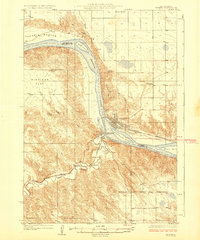
1924 Map of Pierre
USGS Topo · Published 1924About this map
The Missouri River forms the central artery of this 1920s landscape, serving as the county line between Hughes Co and Stanley Co. In this era, the state capital of Pierre and its neighbor across the water, Ft Pierre, are connected by the Chicago and Northwestern railroad, which traces the northern bank of the river. The topography transitions from the alluvial Peoria Bottom to the elevated expanse of Giddings Flat, illustrating the diverse terrain surrounding the confluence of the Bad River.
Find a feature on this map
23 named features on this map. Tap any name to fly to it.
Don’t see what you’re looking for? This feature index may not catch every label — zoom into the map to look around manually.
Map Details
Editions of this 1924 Pierre Map
2 editions found
Other maps of this area

1924 · Pierre
USGS Topo · 1:62,500

1934 · Canning
USGS Topo · 1:48,000

1937 · Canning
USGS Topo · 1:62,500

1937 · Oahe
USGS Topo · 1:62,500

1953 · Teton
USGS Topo · 1:24,000

1953 · Pierre SW
USGS Topo · 1:24,000

1953 · Wendte NE
USGS Topo · 1:24,000

1953 · Pierre 3 NW
USGS Topo · 1:24,000

1954 · Pierre
USGS Topo · 1:250,000

1958 · Pierre
USGS Topo · 1:250,000