
1924 Map of Pierre
USGS Topo · Published 1924About this map
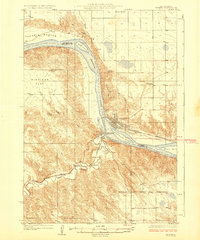
The confluence of the Missouri River and the Bad River serves as the focal point for this survey of the South Dakota state capital during the early 1920s. On the eastern bank, Pierre is shown with its emerging street grid and the Chicago and Northwestern rail line running through the heart of town. Directly across the water sits Ft Pierre, connected to the capital by the railroad bridge and framed by the expansive Laframboise Island.
Find a feature on this map
21 named features on this map. Tap any name to fly to it.
Don’t see what you’re looking for? This feature index may not catch every label — zoom into the map to look around manually.
Map Details
Editions of this 1924 Pierre Map
2 editions found
Other maps of this area

1934 · Canning
USGS Topo · 1:48,000

1937 · Canning
USGS Topo · 1:62,500

1937 · Oahe
USGS Topo · 1:62,500

1953 · Teton
USGS Topo · 1:24,000

1953 · Pierre SW
USGS Topo · 1:24,000

1953 · Wendte NE
USGS Topo · 1:24,000

1953 · Pierre 3 NW
USGS Topo · 1:24,000

1954 · Pierre
USGS Topo · 1:250,000

1958 · Pierre
USGS Topo · 1:250,000

1967 · Pierre NE
USGS Topo · 1:24,000