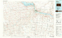
1986 Map of Pierre
USGS Topo · Published 1988About this map
Pierre and Fort Pierre sit at the strategic confluence of the Missouri River and the Bad River, serving as the central hub for this mid-1980s landscape. The geography is defined by the massive engineering of the Missouri, with the waters of Lake Oahe held back to the north and Lake Sharpe stretching to the southeast. These reservoirs are flanked by numerous public areas, including the Oahe Mission Recreation Area and Farm Island Recreation Area, illustrating the region's transition from a wild river corridor to a managed water and recreation system. To the south, the expansive Fort Pierre National Grassland dominates the high plains, while the Chicago and North Western railroad provides a vital east-west transit line through small settlements like Wendte and Canning. The map also preserves the Old Indian Treaty Boundary and the Lower Brule Indian Reservation Boundary, marking the historical intersections of land tenure and governance in South Dakota.
Find a feature on this map
77 named features on this map. Tap any name to fly to it.
Don’t see what you’re looking for? This feature index may not catch every label — zoom into the map to look around manually.
Map Details
Editions of this 1986 Pierre Map
2 editions found
Other maps of this area

1924 · Pierre
USGS Topo · 1:62,500

1934 · Canning
USGS Topo · 1:48,000

1937 · Canning
USGS Topo · 1:62,500

1937 · Oahe
USGS Topo · 1:62,500

1951 · Capa
USGS Topo · 1:24,000

1951 · Van Metre
USGS Topo · 1:24,000

1951 · Capa NW
USGS Topo · 1:24,000

1951 · Capa SE
USGS Topo · 1:24,000

1953 · Teton
USGS Topo · 1:24,000

1953 · Oahe SW
USGS Topo · 1:24,000