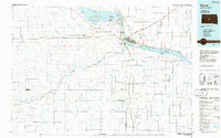
1986 Map of Pierre
USGS Topo · Published 1986About this map
The confluence of the Missouri River and Bad River serves as the focal point for this mid-1980s survey, where the state capital of Pierre stands opposite Fort Pierre. This era is defined by the massive reservoirs created by damming the Missouri, notably Lake Oahe to the north and Lake Sharpe to the south. The landscape transition from the developed riverfront to the expansive Fort Pierre National Grassland reflects the region's ranching and conservation character.
Find a feature on this map
81 named features on this map. Tap any name to fly to it.
Don’t see what you’re looking for? This feature index may not catch every label — zoom into the map to look around manually.
Map Details
Editions of this 1986 Pierre Map
2 editions found
Other maps of this area

1924 · Pierre
USGS Topo · 1:62,500

1934 · Canning
USGS Topo · 1:48,000

1937 · Canning
USGS Topo · 1:62,500

1937 · Oahe
USGS Topo · 1:62,500

1951 · Capa
USGS Topo · 1:24,000

1951 · Van Metre
USGS Topo · 1:24,000

1951 · Capa NW
USGS Topo · 1:24,000

1951 · Capa SE
USGS Topo · 1:24,000

1953 · Teton
USGS Topo · 1:24,000

1953 · Oahe SW
USGS Topo · 1:24,000