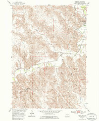
1953 Map of Pierre SW
USGS Topo · Published 1986About this map
Fort Pierre occupies the riverbanks at the convergence of the Bad River and the Missouri, appearing in this 1953 survey as a vital rail and ranching hub. The landscape is defined by the sharp, dissected breaks of the Missouri Plateau, where numerous named drainages like Willow Creek and Porcupine Creek carve through the terrain toward the river valley. The Chicago and North Western railroad parallels the Bad River, anchoring the area's transport network alongside features like the Gaging Sta and a prominent Water Tank.
Find a feature on this map
15 named features on this map. Tap any name to fly to it.
Don’t see what you’re looking for? This feature index may not catch every label — zoom into the map to look around manually.
Map Details
Editions of this 1953 Pierre SW Map
2 editions found
Other maps of this area

1924 · Pierre
USGS Topo · 1:62,500

1937 · Oahe
USGS Topo · 1:62,500

1953 · Teton
USGS Topo · 1:24,000

1953 · Pierre SW
USGS Topo · 1:24,000

1953 · Wendte NE
USGS Topo · 1:24,000

1953 · Pierre 3 NW
USGS Topo · 1:24,000

1954 · Pierre
USGS Topo · 1:250,000

1958 · Pierre
USGS Topo · 1:250,000

1967 · Pierre NE
USGS Topo · 1:24,000
1972 · Pierre 3 NE
USGS Topo · 1:24,000