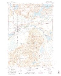
1954 Map of Pillager
USGS Topo · Published 1980About this map
The Crow Wing River snakes through this landscape, marking the natural boundary between Cass and Morrison counties. The village of Pillager serves as a local hub along the Northern Pacific railroad, characterized by its proximity to the Pillager Dam and several community burial sites, including Wildwood Cem and Pillager Cem. This mid-century survey captures the region just as the northern woods were being formally protected within the Pillsbury State Forest.
Find a feature on this map
28 named features on this map. Tap any name to fly to it.
Don’t see what you’re looking for? This feature index may not catch every label — zoom into the map to look around manually.
Map Details
Editions of this 1954 Pillager Map
4 editions found
Other maps of this area

1916 · Pillager
USGS Topo · 1:62,500

1919 · Pillager
USGS Topo · 1:62,500

1948 · Belle Prairie
USGS Topo · 1:62,500

1948 · Cushing
USGS Topo · 1:62,500

1950 · Belle Prairie
USGS Topo · 1:62,500

1950 · Cushing
USGS Topo · 1:62,500

1953 · Brainerd
USGS Topo · 1:250,000

1954 · Baxter
USGS Topo · 1:24,000

1954 · Pillager
USGS Topo · 1:24,000
1956 · Belle Prairie NW
USGS Topo · 1:24,000