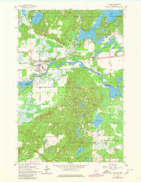
1954 Map of Pillager
USGS Topo · Published 1980About this map
The Crow Wing River snakes through this central Minnesota landscape, defining the transition between the rolling woodlands of Pillsbury State Forest and the vast Camp Ripley Military Reservation. The village of Pillager serves as a local hub along the Pacific Northern railroad, situated near the confluence where Pillager Creek meets the larger river system. Significant mid-century water management is evident at the Pillager Dam Spillway 1199 and the Sylvan Dam Spillway 1177, which control the levels of Lake Placid and the Gull River. Genealogists and local historians will find several burial sites including Wildwood Cem and Pillager Cem, while the inclusion of the Fish Hatchery and numerous lakes like Rice Lake and Sylvan Lake underscores the region's long-standing connection to timber and aquatic resources.
Find a feature on this map
31 named features on this map. Tap any name to fly to it.
Don’t see what you’re looking for? This feature index may not catch every label — zoom into the map to look around manually.
Map Details
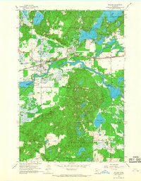
Editions of this 1954 Pillager Map
4 editions found
Other maps of this area

1916 · Pillager
USGS Topo · 1:62,500

1919 · Pillager
USGS Topo · 1:62,500

1948 · Belle Prairie
USGS Topo · 1:62,500

1948 · Cushing
USGS Topo · 1:62,500

1950 · Belle Prairie
USGS Topo · 1:62,500

1950 · Cushing
USGS Topo · 1:62,500

1953 · Brainerd
USGS Topo · 1:250,000

1954 · Baxter
USGS Topo · 1:24,000

1954 · Pillager
USGS Topo · 1:24,000
1956 · Belle Prairie NW
USGS Topo · 1:24,000