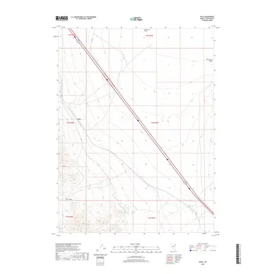
2018 Map of Pilot
USGS Topo · Published 2018About this map
Pilot Creek Valley dominates the eastern portion of this Elko County landscape, where the high desert terrain transitions into the alluvial flats of the basin. The 2018 survey reveals a sparse network of infrastructure defined primarily by the diagonal transit of a major highway corridor and the winding path of Pilot Rd. This region of northeastern Nevada is characterized by its wide basins and isolated water features, such as the Playa Reservoir situated at the southern end of the valley near Morris Basin. The map provides a detailed look at the Public Land Survey System grid, documenting the township and range boundaries that organize this remote stretch of the Great Basin. Local landmarks like the peak of Pilot serve as critical navigational points in a terrain shaped by dramatic elevation changes and seasonal water catchments.
Find a feature on this map
11 named features on this map. Tap any name to fly to it.
Don’t see what you’re looking for? This feature index may not catch every label — zoom into the map to look around manually.
Map Details
Editions of this 2018 Pilot Map
This is the sole edition of this map. No revisions or reprints were ever made.
Other maps of this area

1955 · Elko
USGS Topo · 1:250,000

1958 · Elko
USGS Topo · 1:250,000

1962 · Elko
USGS Topo · 1:250,000

1965 · Elko
USGS Topo · 1:250,000

1971 · West Morris Basin
USGS Topo · 1:24,000
1971 · Silver Zone Pass
USGS Topo · 1:24,000
1971 · Miners Canyon
USGS Topo · 1:24,000

1971 · Pilot
USGS Topo · 1:24,000

1971 · Leppy Peak
USGS Topo · 1:24,000
1971 · Leppy Peak NW
USGS Topo · 1:24,000