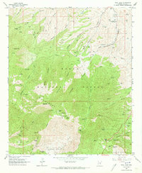
1964 Map of Pinal Peak
USGS Topo · Published 1973About this map
Pinal Peak and Signal Peak anchor this mid-1960s survey of the high Arizona backcountry within the Tonto National Forest. The landscape is defined by the steep drainage systems of Sixshooter Canyon, Icehouse Canyon, and Kellner Canyon, which create a complex network of ridges and basins. Evidence of the region's mining and ranching history is visible in the scattered presence of the Azurite Mine, Harvey Mine, and a Mill located near Bobtail Ridge, alongside small outposts like 66 Ranch. Cultural sites of significance include the Southwest Archeological Center (Gila Pueblo) at the northern edge. The map captures a transition in land use, showing recreational developments such as the Pinal Recreation Area and Pioneer Pass Campground established alongside the older industrial footprints of the Pinal Mountains.
Find a feature on this map
89 named features on this map. Tap any name to fly to it.
Don’t see what you’re looking for? This feature index may not catch every label — zoom into the map to look around manually.
Map Details
Editions of this 1964 Pinal Peak Map
4 editions found
Other maps of this area

1901 · Globe
USGS Topo · 1:62,500

1902 · Globe
USGS Topo · 1:62,500

1910 · Ray
USGS Topo · 1:62,500

1915 · Christmas
USGS Topo · 1:62,500

1917 · Christmas
USGS Topo · 1:62,500

1945 · Globe
USGS Topo · 1:24,000

1945 · Inspiration
USGS Topo · 1:24,000

1947 · Inspiration
USGS Topo · 1:24,000

1948 · Pinal Ranch
USGS Topo · 1:24,000

1949 · Pinal Ranch
USGS Topo · 1:24,000