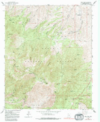
1964 Map of Pinal Peak
USGS Topo · Published 1991About this map
The Pinal Mountains dominate this 1964 survey, centered on the high elevations of Tonto National Forest. Rising toward Pinal Peak, the landscape is defined by a network of steep drainages such as Icehouse Canyon, Sixshooter Canyon, and Kellner Canyon. Mining activity is evident throughout the terrain, with sites like the Azurite Mine, Westlake Mine, and Harvey Mine marking the mountain slopes. The presence of the Southwest Archeological Center (Gila Pueblo) near the northeast corner suggests the deep cultural history of the area.
Find a feature on this map
92 named features on this map. Tap any name to fly to it.
Don’t see what you’re looking for? This feature index may not catch every label — zoom into the map to look around manually.
Map Details
Editions of this 1964 Pinal Peak Map
4 editions found
Other maps of this area

1901 · Globe
USGS Topo · 1:62,500

1902 · Globe
USGS Topo · 1:62,500

1910 · Ray
USGS Topo · 1:62,500

1915 · Christmas
USGS Topo · 1:62,500

1917 · Christmas
USGS Topo · 1:62,500

1945 · Globe
USGS Topo · 1:24,000

1945 · Inspiration
USGS Topo · 1:24,000

1947 · Inspiration
USGS Topo · 1:24,000

1948 · Pinal Ranch
USGS Topo · 1:24,000

1949 · Pinal Ranch
USGS Topo · 1:24,000