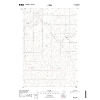
2020 Map of Pine City
USGS Topo · Published 2020About this map
Pine City serves as the primary settlement on this eastern Washington landscape, situated near the intersection of the Pine City Malden Rd and the former rail corridor now designated as the Palouse To Cascades State Park Trail. The topography is defined by the winding drainages of Rock Cr, Pine Cr, and Kamiache Cr, which carve through the high basalt plateau of Whitman County. Local history is anchored by the Pine City Cem and the small communities of Kenova and Hole-In-The-Ground. The road network, including Texas Ferry Rd and Hole-In-The-Ground Rd, follows the natural contours of the coulees, illustrating how the physical geography of the Palouse region has dictated travel and settlement patterns well into the modern era.
Find a feature on this map
30 named features on this map. Tap any name to fly to it.
Don’t see what you’re looking for? This feature index may not catch every label — zoom into the map to look around manually.
Map Details
Editions of this 2020 Pine City Map
This is the sole edition of this map. No revisions or reprints were ever made.
Other maps of this area

1903 · Oakesdale
USGS Topo · 1:125,000

1905 · Oakesdale
USGS Topo · 1:125,000

1954 · Cheney
USGS Topo · 1:62,500

1954 · Spangle
USGS Topo · 1:62,500

1955 · Spokane
USGS Topo · 1:250,000

1958 · Spokane
USGS Topo · 1:250,000

1964 · St. John
USGS Topo · 1:24,000

1964 · Malden
USGS Topo · 1:24,000

1964 · Rock Lake
USGS Topo · 1:24,000
1964 · Thornton
USGS Topo · 1:24,000