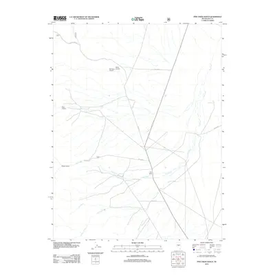
2012 Map of Pine Creek Ranch
USGS Topo · Published 2012About this map
Pine Creek Ranch serves as the primary landmark in this high-desert landscape of central Nevada, situated near the confluence of several seasonal watercourses. The drainage patterns of Pine Creek, Andrews Creek, and Cow Creek reveal a complex system of alluvial fans and canyon exits, characterizing the geography of the Toiyabe National Forest area. The map documents an extensive network of service roads, including Modres Creek Rd and various National Forest Development routes like Nfd 008 Rd, which provide access to the remote canyon systems.
Find a feature on this map
15 named features on this map. Tap any name to fly to it.
Don’t see what you’re looking for? This feature index may not catch every label — zoom into the map to look around manually.
Map Details
Editions of this 2012 Pine Creek Ranch Map
This is the sole edition of this map. No revisions or reprints were ever made.
Other maps of this area

1956 · Tonopah
USGS Topo · 1:250,000

1959 · Tonopah
USGS Topo · 1:250,000

1962 · Tonopah
USGS Topo · 1:250,000

1971 · Corcoran Canyon
USGS Topo · 1:24,000

1971 · Barley Creek
USGS Topo · 1:24,000

1971 · Mosquito Creek
USGS Topo · 1:24,000
1971 · Jet Spring
USGS Topo · 1:24,000
1971 · Box Spring
USGS Topo · 1:24,000
1971 · Northumberland Pass
USGS Topo · 1:24,000

1971 · Jefferson
USGS Topo · 1:24,000