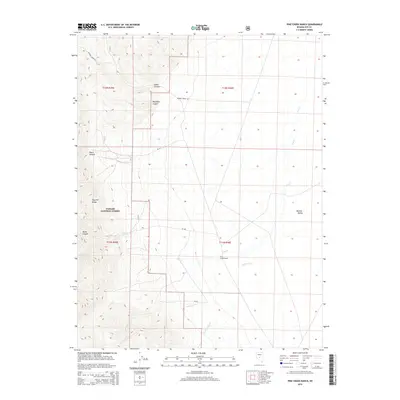
2015 Map of Pine Creek Ranch
USGS Topo · Published 2015About this map
Pine Creek Ranch sits at the geological transition between the high peaks of the Toquima Range and the broad expanse of Monitor Valley. This 2015 topographic survey documents the drainage systems that define the high desert landscape, including Pine Cr, Andrews Cr, and Trail Canyon Cr. Much of the western terrain is protected within the Toiyabe National Forest, where steep drainages like Bucks Canyon and Pasco Canyon cut through the range's eastern flank.
Find a feature on this map
20 named features on this map. Tap any name to fly to it.
Don’t see what you’re looking for? This feature index may not catch every label — zoom into the map to look around manually.
Map Details
Editions of this 2015 Pine Creek Ranch Map
This is the sole edition of this map. No revisions or reprints were ever made.
Other maps of this area

1956 · Tonopah
USGS Topo · 1:250,000

1959 · Tonopah
USGS Topo · 1:250,000

1962 · Tonopah
USGS Topo · 1:250,000

1971 · Corcoran Canyon
USGS Topo · 1:24,000

1971 · Barley Creek
USGS Topo · 1:24,000

1971 · Mosquito Creek
USGS Topo · 1:24,000
1971 · Jet Spring
USGS Topo · 1:24,000
1971 · Box Spring
USGS Topo · 1:24,000
1971 · Northumberland Pass
USGS Topo · 1:24,000

1971 · Jefferson
USGS Topo · 1:24,000