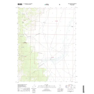
2018 Map of Pine Creek Ranch
USGS Topo · Published 2018About this map
The Toquima Range dominates this landscape, where steep canyons and high ridges descend toward the wide expanse of Monitor Valley. Within the protected boundaries of the Toiyabe National Forest, the map details a rugged transition from high-elevation terrain down to the valley floor. Pine Creek Ranch sits as a primary point of interest at the base of the mountains, positioned near where Pine Cr flows out of the highlands.
Find a feature on this map
26 named features on this map. Tap any name to fly to it.
Don’t see what you’re looking for? This feature index may not catch every label — zoom into the map to look around manually.
Map Details
Editions of this 2018 Pine Creek Ranch Map
This is the sole edition of this map. No revisions or reprints were ever made.
Other maps of this area

1956 · Tonopah
USGS Topo · 1:250,000

1959 · Tonopah
USGS Topo · 1:250,000

1962 · Tonopah
USGS Topo · 1:250,000

1971 · Corcoran Canyon
USGS Topo · 1:24,000

1971 · Barley Creek
USGS Topo · 1:24,000

1971 · Mosquito Creek
USGS Topo · 1:24,000
1971 · Jet Spring
USGS Topo · 1:24,000
1971 · Box Spring
USGS Topo · 1:24,000
1971 · Northumberland Pass
USGS Topo · 1:24,000

1971 · Jefferson
USGS Topo · 1:24,000