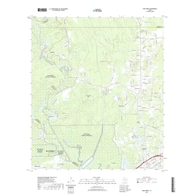
2019 Map of Pine Forest
USGS Topo · Published 2019About this map
The Neches River and Village Creek wind through a landscape defined by the intersection of three counties and the extensive Big Thicket National Preserve. This area north of Beaumont shows a complex network of waterways, including Wiess Canal, Maple Slough, and Banks Bayou, which historically shaped the timber and transport patterns of the region. The map captures the suburban growth around Vidor and Pine Forest, juxtaposed against the preserved swamp and woodland terrain of the Big Thicket. Genealogists can locate several significant burial grounds, including the Williamson Cem in the north and the larger Restlawn Memorial Park and Forest Lawn Memorial Park closer to the residential centers. Distinctive landforms such as Huckleberry Ridge and Ross Ridge rise above the wetlands, providing insight into the natural elevation changes that directed local settlement at Lakeview and Bunns Bluff.
Find a feature on this map
147 named features on this map. Tap any name to fly to it.
Don’t see what you’re looking for? This feature index may not catch every label — zoom into the map to look around manually.
Map Details
Editions of this 2019 Pine Forest Map
This is the sole edition of this map. No revisions or reprints were ever made.
Other maps of this area

1926 · Terry
USGS Topo · 1:24,000

1926 · Lakeview
USGS Topo · 1:24,000

1926 · Vidor
USGS Topo · 1:24,000

1926 · Texla
USGS Topo · 1:24,000

1932 · Beaumont
USGS Topo · 1:62,500

1943 · Terry
USGS Topo · 1:24,000

1943 · Texla
USGS Topo · 1:24,000

1943 · Beaumont East
USGS Topo · 1:24,000

1952 · Lake Charles
USGS Topo · 1:250,000

1954 · Lake Charles
USGS Topo · 1:250,000