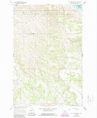
1965 Map of Pine Grove School
USGS Topo · Published 1987About this map
The Charles M Russell National Wildlife Refuge dominates this Garfield County landscape, where the northern breaks meet the waters of Fort Peck Lake. This mid-1960s survey preserves the location of scattered prairie institutions like the Pine Grove Sch and a solitary Cem tucked between the drainages of North Sawmill Creek and South Sawmill Creek. The terrain is defined by dramatic elevation changes, moving from the heights of Herman Ridge and Table Top down to the many coulees and creek beds that feed the Missouri River Basin. Small settlement sites like Dogtown and Leedy mark the thin human footprint in this expansive wildlife territory, while numerous benchmarks like BM 3383 and BM 3286 provide exact topographical reference points for early surveyors and contemporary researchers.
Find a feature on this map
22 named features on this map. Tap any name to fly to it.
Don’t see what you’re looking for? This feature index may not catch every label — zoom into the map to look around manually.
Map Details
Editions of this 1965 Pine Grove School Map
2 editions found
Other maps of this area

1954 · Jordan
USGS Topo · 1:250,000

1956 · Jordan
USGS Topo · 1:250,000

1958 · Jordan
USGS Topo · 1:250,000

1964 · Jordan
USGS Topo · 1:250,000

1965 · Spring Creek School
USGS Topo · 1:24,000

1965 · Lost Creek
USGS Topo · 1:24,000

1965 · Herman Point
USGS Topo · 1:24,000

1965 · Cap Rock Butte
USGS Topo · 1:24,000

1965 · Pine Grove School
USGS Topo · 1:24,000

1965 · Schuyler Butte
USGS Topo · 1:24,000