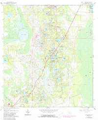
1962 Map of Pine Lakes
USGS Topo · Published 1988About this map
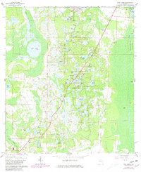
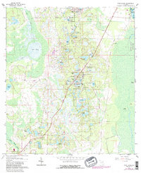
The settlement of Cassia and its adjacent Cassia Cem anchor the southwest corner of this map, reflecting a pocket of high-ground activity in an otherwise water-dominant landscape. The terrain is defined by an intricate network of sinkhole lakes and wetlands, including Lake Tracy, Lake Heron, and the cluster of Pine Lakes and South Pine Lakes. These natural basins dictate the placement of local infrastructure, such as the Old Railroad Grade and a singular Landing Strip. To the east, the boundary between Lake County and Volusia County follows the marshy edges of Hontoon Island State Park and Scrub Island. This map documents a transitional period where small residential areas like Florida Hills and Pine Hills began to materialize amidst the cypress swamps and pine flatwoods, served by landmarks like an Artesian Well and established trails.
Find a feature on this map
54 named features on this map. Tap any name to fly to it.
Don’t see what you’re looking for? This feature index may not catch every label — zoom into the map to look around manually.
Map Details
Editions of this 1962 Pine Lakes Map
4 editions found
Other maps of this area

1954 · Daytona Beach
USGS Topo · 1:250,000

1955 · Orlando
USGS Topo · 1:250,000

1957 · Orlando
USGS Topo · 1:250,000

1958 · Orlando
USGS Topo · 1:250,000

1958 · Daytona Beach
USGS Topo · 1:250,000

1960 · Sorrento
USGS Topo · 1:24,000

1962 · Orlando
USGS Topo · 1:250,000

1962 · Pine Lakes
USGS Topo · 1:24,000

1962 · Lake Woodruff
USGS Topo · 1:24,000

1964 · Daytona Beach
USGS Topo · 1:250,000