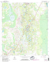
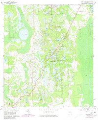
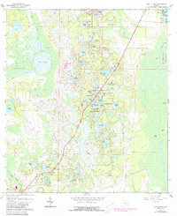
1962 Map of Pine Lakes
USGS Topo · Published 1988About this map
Cassia and its surrounding cypress swamps and pine flatwoods anchor this corner of Lake and Volusia Counties during the early 1960s. The settlement's proximity to the Cassia Cem and the nearby Landing Strip reveals a landscape transitioning between rural agriculture and early recreational development. To the east, the boundary of Hoontoon Island State Park meets the winding course of the St. Johns River, while the interior is defined by a dense cluster of water bodies including Pine Lake, Lake Marion, and Lake Tracy. A prominent Railroad Grade cuts a linear path through the terrain, tracing a legacy of former transport lines that once moved timber through these wetlands. The topographic detail captures a mosaic of islands and mounds, such as Otter Mound and Bush Island, protruding from the low-lying marshes that characterize this central Florida ecosystem.
Find a feature on this map
55 named features on this map. Tap any name to fly to it.
Don’t see what you’re looking for? This feature index may not catch every label — zoom into the map to look around manually.
Map Details
Editions of this 1962 Pine Lakes Map
4 editions found
Other maps of this area

1954 · Daytona Beach
USGS Topo · 1:250,000

1955 · Orlando
USGS Topo · 1:250,000

1957 · Orlando
USGS Topo · 1:250,000

1958 · Orlando
USGS Topo · 1:250,000

1958 · Daytona Beach
USGS Topo · 1:250,000

1960 · Sorrento
USGS Topo · 1:24,000

1962 · Orlando
USGS Topo · 1:250,000

1962 · Pine Lakes
USGS Topo · 1:24,000

1962 · Lake Woodruff
USGS Topo · 1:24,000

1964 · Daytona Beach
USGS Topo · 1:250,000