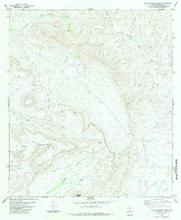
1983 Map of Pine Mountain East
USGS Topo · Published 1984About this map
Pine Mountain dominates this portion of the Brewster County landscape, its high ridges and steep escarpments overlooking a network of seasonal watercourses and high desert basins. During this mid-1970s survey, the area remains characterized by large-scale ranching interests and isolated improvements, such as the Jones site. This arid terrain is defined by dramatic elevation changes, notably at Horseshoe Mesa and the deep incisions of Coffee Pot Canyon. The drainage patterns of San Francisco Creek and Guayule Creek illustrate the natural flow of water through the Trans-Pecos region, where access to water is marked by various Tank locations and a solitary Spring. A complex system of Jeep Trails provides the primary means of navigating this remote frontier, connecting various cattle tanks and high-altitude overlooks.
Find a feature on this map
9 named features on this map. Tap any name to fly to it.
Don’t see what you’re looking for? This feature index may not catch every label — zoom into the map to look around manually.
Map Details
Editions of this 1983 Pine Mountain East Map
2 editions found
Other maps of this area

1918 · Dove Mountain
USGS Topo · 1:62,500

1918 · Bullis Gap
USGS Topo · 1:62,500

1920 · Longfellow
USGS Topo · 1:125,000

1954 · Fort Stockton
USGS Topo · 1:250,000

1958 · Fort Stockton
USGS Topo · 1:250,000

1959 · Emory Peak
USGS Topo · 1:250,000

1965 · Emory Peak
USGS Topo · 1:250,000

1968 · Tesnus
USGS Topo · 1:24,000

1968 · Fresno Creek
USGS Topo · 1:24,000
1968 · Tesnus SE
USGS Topo · 1:24,000