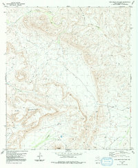
1983 Map of Pine Mountain East
USGS Topo · Published 1992About this map
Pine Mountain dominates the southwestern quadrant of this West Texas landscape, providing a topographical anchor for the surrounding desert drainage systems. The map, based on 1970s aerial photography, captures a network of ephemeral water sources and stock tanks vital to ranching operations in Brewster County. Significant drainages like San Francisco Creek and Guayule Creek carve through the arid terrain, while names like Coffee Pot Canyon and Horseshoe Mesa suggest the long-standing vernacular of local cattlemen and early surveyors. Evidence of human presence is sparse but distinct, marked by a few 4wd tracks and the isolated Jones residence. This survey reflects the persistence of traditional land use in a region where water management, represented by numerous Tank labels, remains the primary concern for any inhabitant.
Find a feature on this map
13 named features on this map. Tap any name to fly to it.
Don’t see what you’re looking for? This feature index may not catch every label — zoom into the map to look around manually.
Map Details
Editions of this 1983 Pine Mountain East Map
2 editions found
Other maps of this area

1918 · Dove Mountain
USGS Topo · 1:62,500

1918 · Bullis Gap
USGS Topo · 1:62,500

1920 · Longfellow
USGS Topo · 1:125,000

1954 · Fort Stockton
USGS Topo · 1:250,000

1958 · Fort Stockton
USGS Topo · 1:250,000

1959 · Emory Peak
USGS Topo · 1:250,000

1965 · Emory Peak
USGS Topo · 1:250,000

1968 · Tesnus
USGS Topo · 1:24,000

1968 · Fresno Creek
USGS Topo · 1:24,000
1968 · Tesnus SE
USGS Topo · 1:24,000