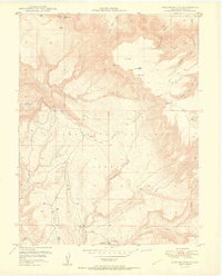
1950 Map of Pine Mountain
USGS Topo · Published 1950About this map
The Uncompahgre National Forest dominates this landscape on the Colorado-Mesa county line, as recorded in a 1950 edition that reflects the post-war interest in western minerals. This specific survey was conducted in collaboration with the United States Atomic Energy Commission, highlighting the region's strategic importance during the early Cold War uranium boom. The terrain is defined by dramatic elevation changes, carved by Calamity Creek, Ute Creek, and Maverick Canyon.
Find a feature on this map
26 named features on this map. Tap any name to fly to it.
Don’t see what you’re looking for? This feature index may not catch every label — zoom into the map to look around manually.
Map Details
Editions of this 1950 Pine Mountain Map
2 editions found
Other maps of this area

1949 · Juanita Arch
USGS Topo · 1:24,000

1949 · Calamity Mesa
USGS Topo · 1:24,000

1949 · Gateway
USGS Topo · 1:24,000

1950 · Juanita Arch
USGS Topo · 1:24,000

1950 · Calamity Mesa
USGS Topo · 1:24,000

1950 · Pine Mountain
USGS Topo · 1:24,000

1952 · Gateway
USGS Topo · 1:24,000

1956 · Moab
USGS Topo · 1:250,000

1959 · Moab
USGS Topo · 1:250,000

1960 · Moab
USGS Topo · 1:250,000