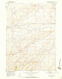
1951 Map of Pine Mountain SW
USGS Topo · Published 1958About this map
The arid grasslands of central Wyoming are defined by the winding course of Poison Spider Creek and the early energy infrastructure that crossed this landscape in the mid-20th century. This 1951 field-checked survey reveals the scattered ranching and oil operations typical of Natrona County, anchored by Dodds Ranch and the isolated West Poison Spider Camp near the eastern edge. A persistent Telephone Line and the Poison Spider Road parallel the drainage, tracing the movement of people and resources between the high ridges like Dodds and the intricate draws below.
Find a feature on this map
16 named features on this map. Tap any name to fly to it.
Don’t see what you’re looking for? This feature index may not catch every label — zoom into the map to look around manually.
Map Details
Editions of this 1951 Pine Mountain SW Map
3 editions found
Other maps of this area

1951 · Pine Mountain SW
USGS Topo · 1:24,000

1951 · Poison Spider
USGS Topo · 1:24,000

1951 · Benton Basin NE
USGS Topo · 1:24,000

1951 · Mc Cleary Reservoir
USGS Topo · 1:24,000

1951 · Square Top Butte
USGS Topo · 1:24,000

1951 · Reid Canyon
USGS Topo · 1:24,000

1955 · Casper
USGS Topo · 1:250,000

1958 · Casper
USGS Topo · 1:250,000

1959 · Gaylord Reservoir
USGS Topo · 1:24,000

1959 · Eightmile Draw
USGS Topo · 1:24,000