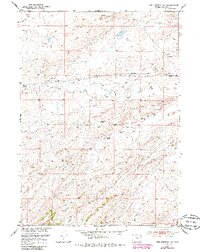
1951 Map of Pine Mountain SW
USGS Topo · Published 1985About this map
Dodds Ranch and West Poison Spider Camp anchor this landscape in central Wyoming, reflecting the region's ranching and early petroleum history during the mid-20th century. The drainage patterns of Poison Spider Creek and its tributaries, including Soap Creek and Austin Creek, dominate the topography. Local transport and infrastructure are marked by the Poison Spider Road, alongside a network of telephone lines and pipelines that signify the area's development. An isolated Oil Well and the prominent Burnt Wagon Draw in the south point to the industrial and historical transit roots of this Natrona County terrain. The survey captures a moment when traditional land use met the expanding energy needs of the Missouri River Basin development program.
Find a feature on this map
16 named features on this map. Tap any name to fly to it.
Don’t see what you’re looking for? This feature index may not catch every label — zoom into the map to look around manually.
Map Details
Editions of this 1951 Pine Mountain SW Map
3 editions found
Other maps of this area

1951 · Pine Mountain SW
USGS Topo · 1:24,000

1951 · Poison Spider
USGS Topo · 1:24,000

1951 · Benton Basin NE
USGS Topo · 1:24,000

1951 · Mc Cleary Reservoir
USGS Topo · 1:24,000

1951 · Square Top Butte
USGS Topo · 1:24,000

1951 · Reid Canyon
USGS Topo · 1:24,000

1955 · Casper
USGS Topo · 1:250,000

1958 · Casper
USGS Topo · 1:250,000

1959 · Gaylord Reservoir
USGS Topo · 1:24,000

1959 · Eightmile Draw
USGS Topo · 1:24,000