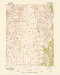
1952 Map of Pine Valley
USGS Topo · Published 1955About this map
Tomera Ranch and Rand Ranch anchor the northern reaches of this high-desert valley, where the irrigation of the arid landscape is evidenced by the presence of a Ditch and a Windmill. The central corridor is defined by the course of Pine Creek, which flows between the towering Cortez Mountains to the west and the Pinon Range to the east. A notable artifact of industrial change is the Dismantled Railroad that follows the valley floor, once connecting the remote ranching outposts to larger markets. In the eastern foothills, the presence of the Indian Campground and Indian Spr near the Smith Creek Basin points to the long-standing significance of water sources in this dry environment. Other family-named locations such as Bailey Ranch, Hay Ranch, and Slagowski Ranch illustrate the mid-century ranching footprint in the Eureka and Elko County borderlands.
Find a feature on this map
38 named features on this map. Tap any name to fly to it.
Don’t see what you’re looking for? This feature index may not catch every label — zoom into the map to look around manually.
Map Details
Editions of this 1952 Pine Valley Map
4 editions found
Other maps of this area

1934 · Jiggs
USGS Topo · 1:125,000

1937 · Mineral Hill
USGS Topo · 1:48,000

1937 · Jiggs
USGS Topo · 1:125,000

1943 · Mineral Hill
USGS Topo · 1:62,500

1952 · Dixie Flats
USGS Topo · 1:62,500

1952 · Pine Valley
USGS Topo · 1:62,500

1952 · Carlin
USGS Topo · 1:62,500

1955 · Winnemucca
USGS Topo · 1:250,000

1955 · Elko
USGS Topo · 1:250,000

1956 · Robinson Mtn
USGS Topo · 1:62,500