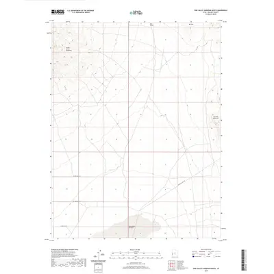
2020 Map of Pine Valley Hardpan North
USGS Topo · Published 2020About this map
Pine Valley Hardpan dominates the southern reaches of this arid Millard County landscape, representing a large ephemeral lake bed characteristic of the Great Basin's endorheic drainage systems. The basin floor of Pine Valley is framed by prominent geological features, including the Tunnel Spring Mountains to the northwest and the northern slopes of the Wah Wah Mountains to the southeast. At the northern edge of the sheet, Mid Mtn rises above the valley floor. The human footprint in this part of western Utah is sparse, defined primarily by a straight-line grid of secondary roads such as W 14900 South St and W 15600 South St. The diagonal path of Pine Valley Well Rd suggests early utility or ranching access to the valley interior, where water management remains the primary driver of regional infrastructure and land use.
Find a feature on this map
9 named features on this map. Tap any name to fly to it.
Don’t see what you’re looking for? This feature index may not catch every label — zoom into the map to look around manually.
Map Details
Editions of this 2020 Pine Valley Hardpan North Map
This is the sole edition of this map. No revisions or reprints were ever made.
Other maps of this area

1953 · Richfield
USGS Topo · 1:250,000

1958 · Richfield
USGS Topo · 1:250,000

1960 · Burbank Hills
USGS Topo · 1:62,500

1960 · Wah Wah Summit
USGS Topo · 1:62,500

1960 · Crystal Peak
USGS Topo · 1:62,500

1971 · Halfway Summit
USGS Topo · 1:24,000

1971 · Tunnel Spring
USGS Topo · 1:24,000

1980 · Wah Wah Mts. North
USGS Topo · 1:100,000
1989 · Wah Wah Summit
USGS Topo · 1:24,000
1989 · Pine Valley Hardpan South
USGS Topo · 1:24,000