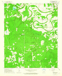
1964 Map of Pinebergen
USGS Topo · Published 1965About this map
Bayou Bartholomew meanders across this landscape, defining the border between Jefferson and Lincoln counties with its winding oxbows and swampy lowlands. The 1964 survey reveals a transition from the structured farm plots of Pinebergen and Hooker in the north to the dense, wet bottomlands of Bradshaw Brake and Fish Lake. This area was a mosaic of rural communities anchored by small institutions, where churches like Shell Chapel and Wheeler Chapel served as local centers alongside scattered Gravel Pits that suggest local industrial activity.
Find a feature on this map
35 named features on this map. Tap any name to fly to it.
Don’t see what you’re looking for? This feature index may not catch every label — zoom into the map to look around manually.
Map Details
Editions of this 1964 Pinebergen Map
3 editions found
Other maps of this area

1935 · Feenyville
USGS Topo · 1:62,500

1935 · Noble Lake
USGS Topo · 1:62,500

1948 · Helena
USGS Topo · 1:250,000

1950 · Helena
USGS Topo · 1:250,000

1953 · Greenwood
USGS Topo · 1:250,000

1953 · El Dorado
USGS Topo · 1:250,000

1955 · Helena
USGS Topo · 1:250,000

1955 · Little Rock
USGS Topo · 1:250,000

1956 · Little Rock
USGS Topo · 1:250,000

1956 · Greenwood
USGS Topo · 1:250,000