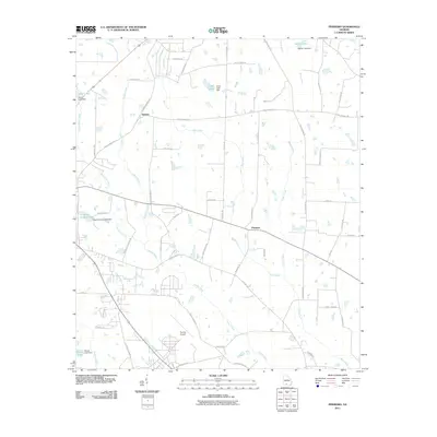
2011 Map of Pineboro
USGS Topo · Published 2011About this map
Pineboro and the rural crossroads of Barbers anchor this Colquitt County landscape, where the agricultural grid is defined by a dense network of slow-moving waterways and small impoundments. The terrain is shaped by the southern flow of Indian Creek and its several tributaries, including the Middle Prong Indian Creek and Little Indian Creek. Numerous small dams have created local landmarks such as Adams Lake, Cobb Lake, and Colquitt County Lake, reflecting the region's managed water resources. To the south, the expansive grounds of Spence Airport occupy a significant portion of the map, illustrating the post-war industrial and aviation footprint in this part of Georgia. Family names are preserved throughout the local road network, with routes like RL Norman Rd, DJ Johnson Rd, and Henry Weeks Rd marking the generations of landholders who established these rural communities.
Find a feature on this map
63 named features on this map. Tap any name to fly to it.
Don’t see what you’re looking for? This feature index may not catch every label — zoom into the map to look around manually.
Map Details
Editions of this 2011 Pineboro Map
This is the sole edition of this map. No revisions or reprints were ever made.
Other maps of this area

1953 · Waycross
USGS Topo · 1:250,000

1956 · Doerun
USGS Topo · 1:62,500

1958 · Waycross
USGS Topo · 1:250,000

1973 · Norman Park
USGS Topo · 1:24,000

1973 · Omega
USGS Topo · 1:24,000

1974 · Berlin East
USGS Topo · 1:24,000
1974 · Sigsbee
USGS Topo · 1:24,000

1974 · Pineboro
USGS Topo · 1:24,000
1974 · Ellenton
USGS Topo · 1:24,000
1978 · Coolidge
USGS Topo · 1:24,000