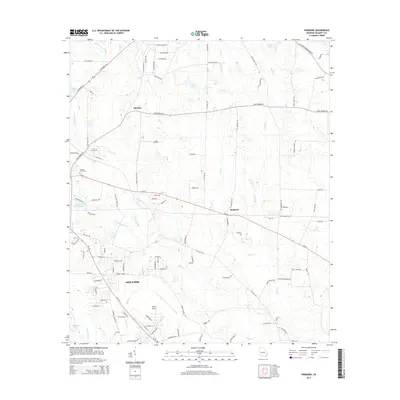
2014 Map of Pineboro
USGS Topo · Published 2014About this map
Spence Airport anchors the southern landscape of this Colquitt County region, serving as a primary landmark just north of the expanding residential and industrial fringes of Moultrie. The geography is defined by a dense network of slow-moving waterways, including Middle Prong Indian Cr, Little Indian Cr, and Bear Cr, which drain the agricultural and timbered lands. Small settlements such as Pineboro and Barbers are connected by a grid of rural roads and highways like Ga-37 and Ga-133.
Find a feature on this map
110 named features on this map. Tap any name to fly to it.
Don’t see what you’re looking for? This feature index may not catch every label — zoom into the map to look around manually.
Map Details
Editions of this 2014 Pineboro Map
This is the sole edition of this map. No revisions or reprints were ever made.
Other maps of this area

1953 · Waycross
USGS Topo · 1:250,000

1956 · Doerun
USGS Topo · 1:62,500

1958 · Waycross
USGS Topo · 1:250,000

1973 · Norman Park
USGS Topo · 1:24,000

1973 · Omega
USGS Topo · 1:24,000

1974 · Berlin East
USGS Topo · 1:24,000
1974 · Sigsbee
USGS Topo · 1:24,000

1974 · Pineboro
USGS Topo · 1:24,000
1974 · Ellenton
USGS Topo · 1:24,000
1978 · Coolidge
USGS Topo · 1:24,000