
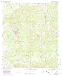
1969 Map of Pinebur
USGS Topo · Published 1971About this map
The Hugh L White Game Reserve anchors this part of southern Mississippi along the border of Marion Co and Lamar Co. In the late 1960s, the rural landscape near the small community of Hub and the settlement of Pinebur remained defined by its complex network of watercourses and piney woods. Water features like Lake Columbia and Lake Watts are prominent, while the terrain is etched by numerous branches including Elbow Prong, Sheep Pen Branch, and Little Turkey Branch. Local landmarks such as Hollywood Spring and a Gaging Station on Beaver Dam Creek suggest the importance of water management in the area. Genealogists may find value in the specific locations of Breakfield and Cook cemeteries, along with Brushy Creek and Pinebur churches, which served as the social and spiritual hubs for these outlying timber and agricultural communities.
Find a feature on this map
33 named features on this map. Tap any name to fly to it.
Don’t see what you’re looking for? This feature index may not catch every label — zoom into the map to look around manually.
Map Details
Editions of this 1969 Pinebur Map
2 editions found
Other maps of this area

1953 · Hattiesburg
USGS Topo · 1:250,000

1958 · Hattiesburg
USGS Topo · 1:250,000

1969 · Baxterville SW
USGS Topo · 1:24,000
1969 · Baxterville
USGS Topo · 1:24,000

1969 · Baxterville NE
USGS Topo · 1:24,000

1970 · Columbia South
USGS Topo · 1:24,000

1970 · Columbia North
USGS Topo · 1:24,000
1970 · Sandy Hook
USGS Topo · 1:24,000

1974 · Oloh
USGS Topo · 1:24,000

1984 · Hattiesburg
USGS Topo · 1:250,000