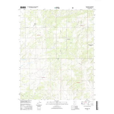
2017 Map of Pinehaven
USGS Topo · Published 2017About this map
Pinehaven sits at the heart of this high-desert landscape in McKinley County, where the dry drainage of Whitewater Arroyo and the deep cuts of Coal Mine Canyon define the local topography. This 2017 survey shows a complex network of local roads and Indian Service routes connecting scattered homesteads and tribal lands. To the west, the Manuelito Canyon area contains the Pinehaven Cem, a significant site for local family history and genealogical research. The eastern portion of the map is dominated by the boundaries of the Cibola National Forest, showing the intersection of public forest lands and Indigenous territory. Water management is critical in this arid environment, evidenced by the presence of the Vanderwagen Reservoir Number Two, Pinos Lake, and several washes like Skeets Wash and Nelson Wash that carry seasonal runoff through the basins.
Find a feature on this map
33 named features on this map. Tap any name to fly to it.
Don’t see what you’re looking for? This feature index may not catch every label — zoom into the map to look around manually.
Map Details
Editions of this 2017 Pinehaven Map
This is the sole edition of this map. No revisions or reprints were ever made.
Other maps of this area

1886 · Wingate
USGS Topo · 1:250,000

1892 · Wingate
USGS Topo · 1:250,000

1954 · Gallup
USGS Topo · 1:250,000

1958 · Gallup
USGS Topo · 1:250,000

1959 · Gallup
USGS Topo · 1:250,000

1962 · Gallup
USGS Topo · 1:250,000

1963 · Twin Buttes
USGS Topo · 1:24,000

1963 · Pinehaven
USGS Topo · 1:24,000
1963 · Upper Nutria
USGS Topo · 1:24,000
1963 · Bread Springs
USGS Topo · 1:24,000