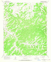
1963 Map of Bread Springs
USGS Topo · Published 1967About this map
Fort Wingate Army Depot dominates the eastern landscape of this McKinley County quadrangle, where the sharp verticality of The Hogback creates a natural boundary. The interior of the map reveals a rugged terrain defined by water management and resource extraction during the early 1960s. Family and tribal landmarks such as Tah Ha Bah Well, Cresto Ranch, and Browns Well are scattered across the canyons, pointing to a community reliant on carefully located water sources in an arid environment.
Find a feature on this map
23 named features on this map. Tap any name to fly to it.
Don’t see what you’re looking for? This feature index may not catch every label — zoom into the map to look around manually.
Map Details
Editions of this 1963 Bread Springs Map
2 editions found
Other maps of this area

1886 · Wingate
USGS Topo · 1:250,000

1892 · Wingate
USGS Topo · 1:250,000

1954 · Gallup
USGS Topo · 1:250,000

1958 · Gallup
USGS Topo · 1:250,000

1959 · Gallup
USGS Topo · 1:250,000

1962 · Gallup
USGS Topo · 1:250,000

1963 · Twin Buttes
USGS Topo · 1:24,000

1963 · Gallup West
USGS Topo · 1:24,000
1963 · Church Rock
USGS Topo · 1:24,000

1963 · Pinehaven
USGS Topo · 1:24,000
Featured Places
- Gallup, NM
- Eastern Navajo Agency, NM
- Sundance, Eastern Navajo Agency
- Bread Springs, Eastern Navajo Agency
- McKinley County, NM