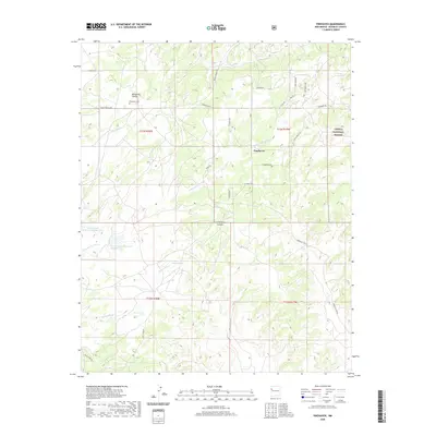
2020 Map of Pinehaven
USGS Topo · Published 2020About this map
Pinehaven sits at the heart of this high-desert landscape in McKinley County, where the transition from open range to the Cibola National Forest is defined by a network of seasonal drainages and canyons. The settlement pattern is largely influenced by the presence of water management features such as Vanderwagen Reservoir Number One and Vanderwagen Reservoir Number Two, alongside Pinos Lake and the Navajo Stock Tank. These landmarks highlight the critical role of water capture in the arid Eastern Navajo Agency. Deep incisions in the earth like Manuelito Canyon and Coal Mine Canyon reveal the complex topography of the region, while the Pinehaven Cem serves as a local historical waypoint for those tracing family roots in the area. A sophisticated network of service roads, including Indian Svc Rte 26 and Bread Springs Rd, connects these remote reaches, reflecting the modern infrastructure supporting tribal and forest lands.
Find a feature on this map
34 named features on this map. Tap any name to fly to it.
Don’t see what you’re looking for? This feature index may not catch every label — zoom into the map to look around manually.
Map Details
Editions of this 2020 Pinehaven Map
This is the sole edition of this map. No revisions or reprints were ever made.
Other maps of this area

1886 · Wingate
USGS Topo · 1:250,000

1892 · Wingate
USGS Topo · 1:250,000

1954 · Gallup
USGS Topo · 1:250,000

1958 · Gallup
USGS Topo · 1:250,000

1959 · Gallup
USGS Topo · 1:250,000

1962 · Gallup
USGS Topo · 1:250,000

1963 · Twin Buttes
USGS Topo · 1:24,000

1963 · Pinehaven
USGS Topo · 1:24,000
1963 · Upper Nutria
USGS Topo · 1:24,000
1963 · Bread Springs
USGS Topo · 1:24,000