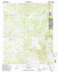
1995 Map of Pinehaven
USGS Topo · Published 1997About this map
Pinehaven serves as a central point in this mid-1990s landscape, where the Cibola National Forest meets the northern reaches of the Zuni Indian Reservation. The geography is defined by a series of drainages and reservoirs, including Vanderwagen Reservoir No 1 and Vanderwagen Reservoir No 2, which manage water flow through the arid terrain. Local community life is reflected in landmarks such as the Navajo Church and the Pinehaven Cemetery, while the small settlement of Nelson lies further south. The map illustrates a region transitioning from forest management to tribal lands, marked by the Third Standard Parallel North. Evidence of local industry or land use appears in the northern sections with a Sand Pit, while natural features like Coal Mine Canyon and Pintos Lake highlight the varied topography of McKinley County.
Find a feature on this map
17 named features on this map. Tap any name to fly to it.
Don’t see what you’re looking for? This feature index may not catch every label — zoom into the map to look around manually.
Map Details
Editions of this 1995 Pinehaven Map
This is the sole edition of this map. No revisions or reprints were ever made.
Other maps of this area

1886 · Wingate
USGS Topo · 1:250,000

1892 · Wingate
USGS Topo · 1:250,000

1954 · Gallup
USGS Topo · 1:250,000

1958 · Gallup
USGS Topo · 1:250,000

1959 · Gallup
USGS Topo · 1:250,000

1962 · Gallup
USGS Topo · 1:250,000

1963 · Twin Buttes
USGS Topo · 1:24,000

1963 · Pinehaven
USGS Topo · 1:24,000
1963 · Upper Nutria
USGS Topo · 1:24,000
1963 · Bread Springs
USGS Topo · 1:24,000