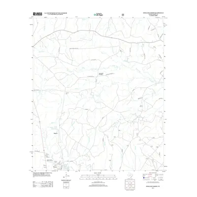
2012 Map of Pineland North
USGS Topo · Published 2012About this map
Pineland serves as a primary settlement anchor in this 2012 survey of Sabine County, situated at the junction of local roads and watercourses. The landscape is defined by an intricate network of creeks and bayous, including Housen Bayou and Pace Cr, which drain the timberlands and hollows such as Housen Holw. This area is notable for its concentration of small family and community burial grounds, which offer significant value for genealogical research in east Texas.
Find a feature on this map
57 named features on this map. Tap any name to fly to it.
Don’t see what you’re looking for? This feature index may not catch every label — zoom into the map to look around manually.
Map Details
Editions of this 2012 Pineland North Map
This is the sole edition of this map. No revisions or reprints were ever made.
Other maps of this area

1953 · Alexandria
USGS Topo · 1:250,000

1953 · Palestine
USGS Topo · 1:250,000

1955 · Alexandria
USGS Topo · 1:250,000

1957 · Palestine
USGS Topo · 1:250,000

1957 · Brookeland
USGS Topo · 1:62,500

1958 · Hemphill
USGS Topo · 1:62,500

1958 · Mc Gee Bend
USGS Topo · 1:62,500

1958 · Bronson
USGS Topo · 1:62,500

1969 · Brookeland
USGS Topo · 1:62,500
1984 · Milam
USGS Topo · 1:24,000