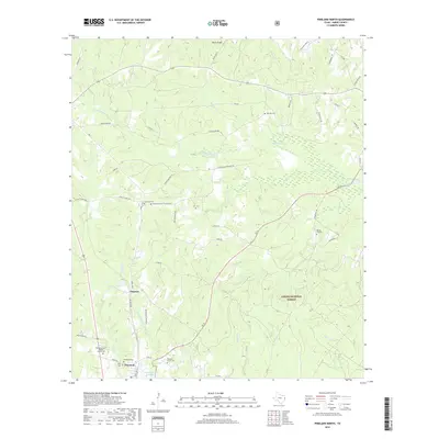
2019 Map of Pineland North
USGS Topo · Published 2019About this map
Pineland and the small settlement of Magasco anchor this modern survey of Sabine County, Texas. This part of East Texas is defined by the dense woodlands of the Sabine National Forest and a complex network of waterways including Housen Bayou and Sixmile Cr. The terrain is marked by notable elevations such as Rosin Ridge and the broad Housen Hollow. Cultural history is well-preserved through numerous rural burial grounds like Pine Hill Cem and Lott Cem, alongside the Bethany Chapel Baptist Church. The local landscape shows the industrial influence of the Temple Rd N corridor and the managed waters of Magasco Lake, reflecting a community deeply tied to both the timber economy and the natural features of the Piney Woods.
Find a feature on this map
70 named features on this map. Tap any name to fly to it.
Don’t see what you’re looking for? This feature index may not catch every label — zoom into the map to look around manually.
Map Details
Editions of this 2019 Pineland North Map
This is the sole edition of this map. No revisions or reprints were ever made.
Other maps of this area

1953 · Alexandria
USGS Topo · 1:250,000

1953 · Palestine
USGS Topo · 1:250,000

1955 · Alexandria
USGS Topo · 1:250,000

1957 · Palestine
USGS Topo · 1:250,000

1957 · Brookeland
USGS Topo · 1:62,500

1958 · Hemphill
USGS Topo · 1:62,500

1958 · Mc Gee Bend
USGS Topo · 1:62,500

1958 · Bronson
USGS Topo · 1:62,500

1969 · Brookeland
USGS Topo · 1:62,500
1984 · Milam
USGS Topo · 1:24,000