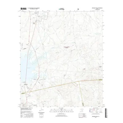
2016 Map of Pineland South
USGS Topo · Published 2016About this map
The timberlands of East Texas define this landscape, where the Sabine National Forest blankets the rolling terrain between the northern settlement of Pineland and Browndell to the south. This area is characterized by a dense network of watercourses, including Devils Ford Cr, McKim Cr, and Sixmile Cr, which eventually feed toward the western edge of the Sam Rayburn Reservoir. The map reveals a history of local families through numerous small burial grounds like Goodwill Cem, Berryman Cem, and Johnson Family Cem, scattered among the pines.
Find a feature on this map
74 named features on this map. Tap any name to fly to it.
Don’t see what you’re looking for? This feature index may not catch every label — zoom into the map to look around manually.
Map Details
Editions of this 2016 Pineland South Map
This is the sole edition of this map. No revisions or reprints were ever made.
Other maps of this area

1953 · Alexandria
USGS Topo · 1:250,000

1953 · Palestine
USGS Topo · 1:250,000

1955 · Alexandria
USGS Topo · 1:250,000

1957 · Palestine
USGS Topo · 1:250,000

1957 · Brookeland
USGS Topo · 1:62,500

1958 · Hemphill
USGS Topo · 1:62,500

1958 · Mc Gee Bend
USGS Topo · 1:62,500

1958 · Bronson
USGS Topo · 1:62,500

1969 · Brookeland
USGS Topo · 1:62,500
1984 · Harrisburg
USGS Topo · 1:24,000