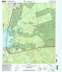
2003 Map of Pineland South
USGS Topo · Published 2004About this map
Sabine National Forest dominates the landscape of this East Texas region, where the eastern shoreline of the Sam Rayburn Reservoir meets a dense network of timberlands and small communities. The map captures the meeting point of Sabine, Jasper, and Newton Counties, centering on the rural settlements of Pineland, Stringtown, and Blackjack. For researchers of local family history, the map is particularly rich in cemetery locations, including the Lowe Cem and Mc Elroy Cemetery, along with several country churches such as Lone Star Ch and Spring Hill Ch.
Find a feature on this map
51 named features on this map. Tap any name to fly to it.
Don’t see what you’re looking for? This feature index may not catch every label — zoom into the map to look around manually.
Map Details
Editions of this 2003 Pineland South Map
This is the sole edition of this map. No revisions or reprints were ever made.
Other maps of this area

1953 · Alexandria
USGS Topo · 1:250,000

1953 · Palestine
USGS Topo · 1:250,000

1955 · Alexandria
USGS Topo · 1:250,000

1957 · Palestine
USGS Topo · 1:250,000

1957 · Brookeland
USGS Topo · 1:62,500

1958 · Hemphill
USGS Topo · 1:62,500

1958 · Mc Gee Bend
USGS Topo · 1:62,500

1958 · Bronson
USGS Topo · 1:62,500

1969 · Brookeland
USGS Topo · 1:62,500
1984 · Harrisburg
USGS Topo · 1:24,000