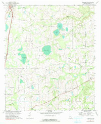
1971 Map of Pineview NW
USGS Topo · Published 1991About this map
Unadilla serves as the primary hub in the northwestern corner of this Dooly County landscape, where the Southern railroad and highway 41 run parallel through the town center. The surrounding terrain is defined by a dense network of blackwater drainages and Carolina bays, most notably the large waters of Pocasin Pond, Alligator Pond, and Layfield Pond. These wetlands are interconnected by numerous creeks, including South Prong Creek and Wildcat Creek, suggesting a landscape historically shaped by timber and agriculture.
Find a feature on this map
25 named features on this map. Tap any name to fly to it.
Don’t see what you’re looking for? This feature index may not catch every label — zoom into the map to look around manually.
Map Details
Editions of this 1971 Pineview NW Map
2 editions found
Other maps of this area

1956 · Perry
USGS Topo · 1:62,500

1957 · Macon
USGS Topo · 1:250,000

1958 · Macon
USGS Topo · 1:250,000

1964 · Macon
USGS Topo · 1:250,000

1971 · Pineview West
USGS Topo · 1:24,000

1971 · Pineview NW
USGS Topo · 1:24,000

1971 · Pineview SW
USGS Topo · 1:24,000

1971 · Henderson
USGS Topo · 1:24,000

1971 · Pinehurst
USGS Topo · 1:24,000

1972 · Finleyson West
USGS Topo · 1:24,000