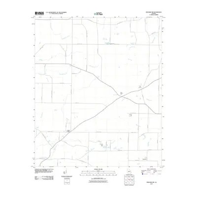
2011 Map of Pineview SW
USGS Topo · Published 2011About this map
Lamb Town and Tremont anchor this portion of Dooly County, Georgia, in the early 2010s, where the landscape is defined by a dense network of country roads and low-lying watercourses. Agricultural legacy is evident in the naming of thoroughfares like Noble Gin Rd and Coody Dairy Rd, while local heritage is preserved at Rock Hill Cemetery and Pleasant Hill Cemetery. The Alapaha River and Pennahatchee Creek drain the region, supplemented by man-made water bodies such as Sangster Lake and Brannon Lake, both held by namesake dams. This survey reflects a quintessential Middle Georgia rural community, where long-established family names like Parham, Sangster, and Lamb are etched into the local geography through road names and small settlements. The Walton Lookout Tower stands as a prominent landmark near the junction of several county routes, providing a fixed point of reference in this creek-veined territory.
Find a feature on this map
58 named features on this map. Tap any name to fly to it.
Don’t see what you’re looking for? This feature index may not catch every label — zoom into the map to look around manually.
Map Details
Editions of this 2011 Pineview SW Map
This is the sole edition of this map. No revisions or reprints were ever made.
Other maps of this area

1953 · Waycross
USGS Topo · 1:250,000

1957 · Macon
USGS Topo · 1:250,000

1958 · Macon
USGS Topo · 1:250,000

1958 · Waycross
USGS Topo · 1:250,000

1964 · Macon
USGS Topo · 1:250,000

1971 · Pineview West
USGS Topo · 1:24,000

1971 · Pineview NW
USGS Topo · 1:24,000

1971 · Pineview SW
USGS Topo · 1:24,000

1971 · Pinehurst
USGS Topo · 1:24,000

1972 · Finleyson West
USGS Topo · 1:24,000