
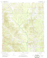
1968 Map of Pineville
USGS Topo · Published 1970About this map
The Bienville National Forest dominates this Central Mississippi landscape, where the Leaf River and its numerous tributaries like Tallabogue Creek and Turkey Creek carve through the terrain. In the late 1960s, the small settlement of Pineville served as a local hub, anchored by the Pineville Ch. The map reveals a transition in land use, showing an Old Railroad Grade that speaks to earlier timber or transit eras, alongside modern industrial markers like an Oil Well and a Drill Hole.
Find a feature on this map
24 named features on this map. Tap any name to fly to it.
Don’t see what you’re looking for? This feature index may not catch every label — zoom into the map to look around manually.
Map Details
Editions of this 1968 Pineville Map
2 editions found
Other maps of this area

1921 · Forest
USGS Topo · 1:48,000

1922 · Forest
USGS Topo · 1:62,500

1922 · Morton
USGS Topo · 1:48,000

1924 · Morton
USGS Topo · 1:62,500

1950 · Forest
USGS Topo · 1:62,500

1951 · Morton
USGS Topo · 1:62,500

1952 · Forest
USGS Topo · 1:62,500

1953 · Meridian
USGS Topo · 1:250,000

1957 · Meridian
USGS Topo · 1:250,000

1965 · Meridian
USGS Topo · 1:250,000