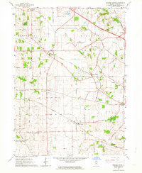
1962 Map of Pingree Grove
USGS Topo · Published 1964About this map
The Hampshire Forest Preserve and a network of arterial railways define this landscape in north-central Kane County. The map documents a critical period of infrastructure growth, featuring the newly constructed Northwest Tollway cutting across the northern sections, while the long-established Chicago and North Western and Illinois Central lines continue to serve the small crossroads communities. Small rural hubs like Plato Center, North Plato, and Allens Corners remain concentrated around their original transit points, often anchored by local institutions such as Central High Sch.
Find a feature on this map
57 named features on this map. Tap any name to fly to it.
Don’t see what you’re looking for? This feature index may not catch every label — zoom into the map to look around manually.
Map Details
Editions of this 1962 Pingree Grove Map
2 editions found
Other maps of this area

1925 · Elgin
USGS Topo · 1:62,500

1932 · Geneva
USGS Topo · 1:62,500

1937 · Sycamore
USGS Topo · 1:62,500

1938 · Genoa
USGS Topo · 1:62,500

1940 · Elgin
USGS Topo · 1:62,500

1948 · Geneva
USGS Topo · 1:62,500

1949 · Geneva
USGS Topo · 1:24,000

1954 · Rockford
USGS Topo · 1:250,000

1955 · Rockford
USGS Topo · 1:250,000

1958 · Aurora
USGS Topo · 1:250,000