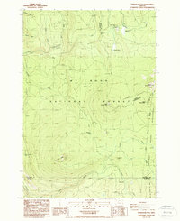
1986 Map of Pinhead Buttes
USGS Topo · Published 1988About this map
Mt Hood National Forest and the Warm Springs Indian Reservation converge in this high-altitude landscape dominated by the volcanic forms of the Pinhead Buttes. The 1980s terrain is marked by a network of drainage systems, including the Clackamas River and Lemiti River, which carve through the timbered uplands. Human presence is defined by resource management and recreation, evidenced by several Borrow Pits and the prominence of the Sisi Lookout Tower atop Sisi Butte. The map documents a significant segment of the Pacific Crest National Scenic Trail as it skirts the eastern boundary of the forest near North Pinhead Butte. This area serves as a critical watershed, where seasonal meadows like Warm Springs Meadow and Trapper Spring Meadow provide natural openings in the dense canopy, while local color is preserved in labels like Poop Creek and Bear Skull Spring.
Find a feature on this map
36 named features on this map. Tap any name to fly to it.
Don’t see what you’re looking for? This feature index may not catch every label — zoom into the map to look around manually.
Map Details
Editions of this 1986 Pinhead Buttes Map
4 editions found
Other maps of this area

1924 · Mount Hood
USGS Topo · 1:125,000

1927 · Mount Hood
USGS Topo · 1:125,000

1927 · Mt. Jefferson
USGS Topo · 1:125,000

1930 · Mt. Jefferson
USGS Topo · 1:125,000

1953 · The Dalles
USGS Topo · 1:250,000

1955 · Bend
USGS Topo · 1:250,000

1956 · The Dalles
USGS Topo · 1:250,000

1956 · High Rock
USGS Topo · 1:62,500

1956 · Mt. Wilson
USGS Topo · 1:62,500

1957 · Bend
USGS Topo · 1:250,000