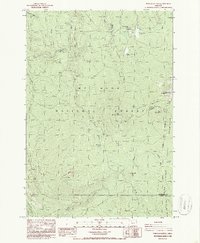
1986 Map of Pinhead Buttes
USGS Topo · Published 1986About this map
Mt Hood National Forest and the Warm Springs Indian Reservation converge in this high-altitude landscape dominated by the namesake Pinhead Buttes. The survey captures a high-mountain environment defined by steep drainages and strategic overlooks, most notably the Sisi Lookout Tower atop Sisi Butte. This peak serves as a sentinel over the surrounding wilderness, where the Pacific Crest National Scenic Trail winds along the eastern ridgelines. The mapping of this era highlights the complex hydrography of the region, from the headwaters of the Warm Springs River to the smaller Lemiti Creek and Campbell Creek. Local industrial activity is evidenced by several Borrow Pits and a Quarry, while natural landmarks like Bear Skull Spring and Warm Springs Meadow provide essential reference points for navigating the timbered slopes and high meadows.
Find a feature on this map
33 named features on this map. Tap any name to fly to it.
Don’t see what you’re looking for? This feature index may not catch every label — zoom into the map to look around manually.
Map Details
Editions of this 1986 Pinhead Buttes Map
4 editions found
Other maps of this area

1924 · Mount Hood
USGS Topo · 1:125,000

1927 · Mount Hood
USGS Topo · 1:125,000

1927 · Mt. Jefferson
USGS Topo · 1:125,000

1930 · Mt. Jefferson
USGS Topo · 1:125,000

1953 · The Dalles
USGS Topo · 1:250,000

1955 · Bend
USGS Topo · 1:250,000

1956 · The Dalles
USGS Topo · 1:250,000

1956 · High Rock
USGS Topo · 1:62,500

1956 · Mt. Wilson
USGS Topo · 1:62,500

1957 · Bend
USGS Topo · 1:250,000