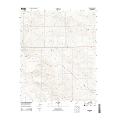
2013 Map of Pink Peak
USGS Topo · Published 2013About this map
Chupadera Mesa dominates the high desert landscape of Socorro County in this 2013 topographic study. The terrain is defined by a network of drainage systems including Lutz Canyon in the north and Red Canyon to the south, converging toward the lowlands. The small settlement of Naulda sits along the southern transit corridor, where Us-380 cuts diagonally across the township lines of t6s r8e.
Find a feature on this map
16 named features on this map. Tap any name to fly to it.
Don’t see what you’re looking for? This feature index may not catch every label — zoom into the map to look around manually.
Map Details
Editions of this 2013 Pink Peak Map
This is the sole edition of this map. No revisions or reprints were ever made.
Other maps of this area

1918 · Oscura Peak
USGS Topo · 1:125,000

1948 · Broken Back Crater
USGS Topo · 1:62,500

1948 · Bingham
USGS Topo · 1:62,500

1948 · Chihuahua Ranch
USGS Topo · 1:62,500

1948 · Mockingbird Gap
USGS Topo · 1:62,500

1954 · Tularosa
USGS Topo · 1:250,000

1958 · Tularosa
USGS Topo · 1:250,000
1981 · Broken Back Crater
USGS Topo · 1:24,000
1981 · Cooper Canyon
USGS Topo · 1:24,000
1982 · Wagon Canyon
USGS Topo · 1:24,000