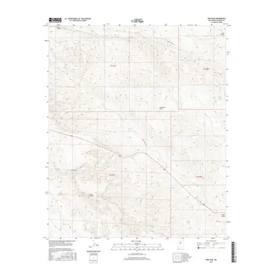
2017 Map of Pink Peak
USGS Topo · Published 2017About this map
Pink Peak rises as a prominent landmark within this arid reach of the high desert, where deep drainages like Lutz Canyon and Lobo Canyon cut through the rugged topography. The terrain is characterized by the broad, elevated expanse of Chupadera Mesa, a landform that dictates the local drainage patterns toward Red Canyon and Taylor Canyon. Human presence is marked primarily by ranching infrastructure and desert transit routes, including WSMR 5 Route 1506. Strategic water points such as Monk Tank, Taylor Tank, and the curiously named School Section Tank illustrate the critical importance of water management in this Socorro County landscape. These features, though sparse, indicate a legacy of land use tied to grazing and government range management in a region where elevation changes significantly over short distances.
Find a feature on this map
14 named features on this map. Tap any name to fly to it.
Don’t see what you’re looking for? This feature index may not catch every label — zoom into the map to look around manually.
Map Details
Editions of this 2017 Pink Peak Map
This is the sole edition of this map. No revisions or reprints were ever made.
Other maps of this area

1918 · Oscura Peak
USGS Topo · 1:125,000

1948 · Broken Back Crater
USGS Topo · 1:62,500

1948 · Bingham
USGS Topo · 1:62,500

1948 · Chihuahua Ranch
USGS Topo · 1:62,500

1948 · Mockingbird Gap
USGS Topo · 1:62,500

1954 · Tularosa
USGS Topo · 1:250,000

1958 · Tularosa
USGS Topo · 1:250,000
1981 · Broken Back Crater
USGS Topo · 1:24,000
1981 · Cooper Canyon
USGS Topo · 1:24,000
1982 · Wagon Canyon
USGS Topo · 1:24,000