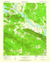
1961 Map of Pinnacle Mountain
USGS Topo · Published 1962About this map
Pinnacle Mountain and the Fulk Mountains dominate this 1961 landscape west of Little Rock, where the Arkansas River bends south past the community of Natural Steps. The map reveals a transition from the river's floodplain to high peaks like Shinall Mountain, which serves as a hub for communication, noted by its collection of (KTHV) (KARK-TV) Radio Towers. Local life is anchored by small settlements such as Ivesville and Pankey Addition, while the Chicago Rock Island and Pacific Railroad skirts the southern edge of Big Rock. Genealogists will find a high density of burial sites including the Old Soldiers Cem and State Hospital Cem, alongside civic landmarks like the County Prison Farm and Robinson Sch. The presence of an aqueduct and the Pumping Station at Lake Maumelle highlights the critical water infrastructure supporting the growing metropolitan area.
Find a feature on this map
57 named features on this map. Tap any name to fly to it.
Don’t see what you’re looking for? This feature index may not catch every label — zoom into the map to look around manually.
Map Details
Editions of this 1961 Pinnacle Mountain Map
4 editions found
Other maps of this area

1890 · Benton
USGS Topo · 1:125,000

1891 · Little Rock
USGS Topo · 1:125,000

1893 · Little Rock
USGS Topo · 1:125,000

1894 · Benton
USGS Topo · 1:125,000

1935 · Little Rock
USGS Topo · 1:24,000

1935 · North Little Rock
USGS Topo · 1:24,000

1935 · Alexander
USGS Topo · 1:48,000

1938 · Benton
USGS Topo · 1:48,000

1941 · Alexander
USGS Topo · 1:62,500

1943 · Pinnacle Mtn
USGS Topo · 1:31,680