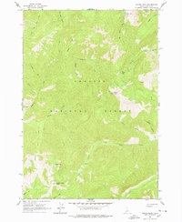
1963 Map of Pinyon Peak
USGS Topo · Published 1978About this map
Challis National Forest land defines this central Idaho terrain, dominated by the high elevation of Pinyon Peak and the neighboring Feltham Creek Point. Each of these summits features a designated lookout, reflecting the critical fire-watch infrastructure maintained by the Department of the Interior during the mid-twentieth century. The landscape is characterized by a dense network of drainages including Loon Creek and Duffield Creek, which carved deep canyons and gulches like Packer Gulch.
Find a feature on this map
33 named features on this map. Tap any name to fly to it.
Don’t see what you’re looking for? This feature index may not catch every label — zoom into the map to look around manually.
Map Details
Editions of this 1963 Pinyon Peak Map
3 editions found
Other maps of this area

1891 · Bear Valley
USGS Topo · 1:125,000

1893 · Bear Valley
USGS Topo · 1:125,000

1919 · Custer
USGS Topo · 1:125,000

1922 · Custer
USGS Topo · 1:125,000

1930 · Casto
USGS Topo · 1:125,000

1957 · Challis
USGS Topo · 1:250,000

1960 · Challis
USGS Topo · 1:250,000

1961 · Greyhound Ridge
USGS Topo · 1:62,500

1963 · Challis
USGS Topo · 1:250,000

1963 · Pinyon Peak
USGS Topo · 1:24,000